
The development of what we recognize today as the Quillayute Prairie resulted from millions of years of geologic processes, some quite widespread and regional, and some much more localized. Many of the rocks that comprise the Olympic Peninsula originated as oceanic seafloor far away to the west. These rocks were transported eastward thousands of kilometers across the Pacific Ocean and adhered to the North American continent, all the result of plate tectonics and the action of the Cascadia Subduction Zone. Locally, at the Earth’s surface, these rocks and Quillayute Prairie's landscape have been formed and sculpted by climate-related depositional and erosional processes, most notably: glaciers, rivers, and landsliding.
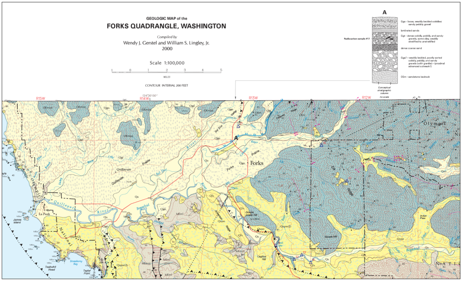
Figure 1.
Section of the geologic map of the Forks Quadrangle. Rock and sedimentary units are distinguished by color and symbols. Blue units to the north and east of the map illustrate where 33-23 million year-old marine sedimentary rocks are located; gray/pink units to the south and east illustrate the locations of 23-5 million year-old marine sedimentary rocks; pale yellow units signify unlithified sedimentary deposits from the last 2.5 million years to today. ‘Unlithified sediment’ refers to individual grains of clay, silt, sand, pebbles, and other gravel clustered as you may find on a beach or in a stream bed.
Note that the Quillayute Prairie resides on a pale-yellow unit with small triangles labeled ‘Qgt’. Qgt is a unit of unlithified glacial till sediments deposited by the expansion, grinding actions, and subsequent melting of glaciers between 25 and 10 thousand years ago. https://www.dnr.wa.gov/publications/ger_geologic_maps_wa.pdf
A subduction zone refers to a tectonic process in which one of the tectonic plates covering Earth’s surface is overridden by a neighboring tectonic plate plate as the two place are forced to converge toward one another. In the Cascadia Subduction Zone the oceanic Juan de Fuca Plate, located just offshore of Washington and Oregon, is sliding beneath the North American Plate - on which our continent resides. The seafloor Juan de Fuca rocks are denser than the continental North American rocks, so the oceanic plate is naturally forced to ‘sink’ beneath the less-dense continental plate.
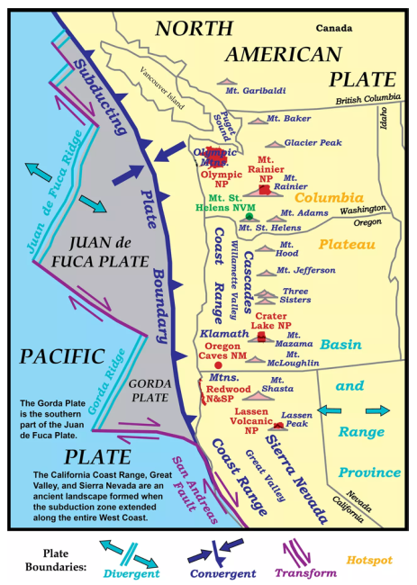
Figure 2.
Image Illustrating the tectonic plates of the Pacific Northwest. Note that Washington State resides on the continental North American plate which converges towards the oceanic Juan de Fuca plate. The boundary between these plates is referred to as the Cascadia Subduction Zone, which can generate massive earthquakes and resultant tsunami. https://www.nps.gov/subjects/geology/plate-tectonics-subduction-zones.htm
The forces of subduction along our coastline lead to the uplift of earth, resulting in a process called orogeny or ‘mountain building.’ The Cascadia subduction zone is associated with two major types of mountain building: the first formed the Olympic mountains, where shallow layers of volcanic and sedimentary rocks are scraped off the subducting oceanic plate and pasted onto the North American continent in a process known as accretion. The accreted rocks are then squeezed up by the immense pressures involved in subduction and exposed at the surface by weathering and erosion. These rocks underlie the sediments of the Quillayute Prairie and constitute the rocks of the Olympic Mountains. The second type of mountain building forms the Cascade Range through mantle melting, magmatic injection, and volcanic eruption processes.
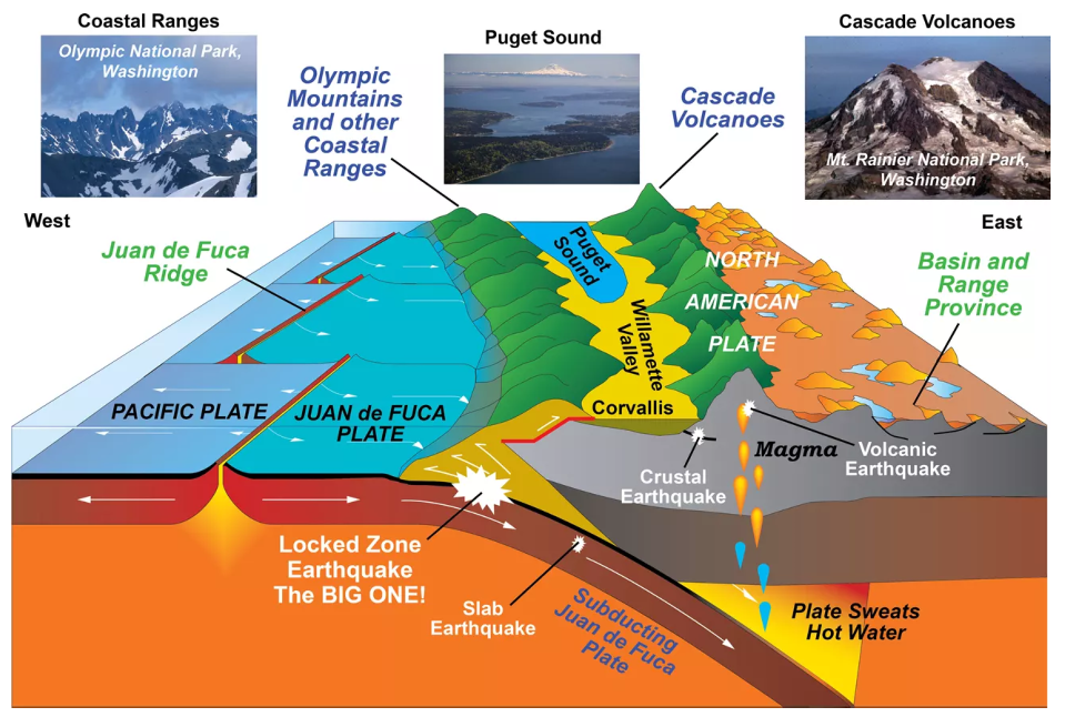
Figure 3.
In Cascadia the oceanic Juan de Fuca plate is forced to ‘sink’ under the more buoyant (lessdense) North American plate. This process has formed the Olympic Mountains near the convergence margin and the Cascade Mountain Range further inland. https://www.nps.gov/subjects/geology/plate-tectonics-subduction-zones.htm
As the subducting Juan de Fuca plate descends underneath the North American plate, it does so spasmodically. For most of the time the two plates are locked against each other, preventing slipping and causing the overriding plate to bulge upwards. Eventually, the mounting stress between the two plates triggers a rupture and they quickly slide past each other. Offshore, the outer edge of the overriding plate lunges back up, displacing ocean water and initiating tsunami waves. This process releases a great deal of energy, generating the massive earthquakes we associate with subduction zones.
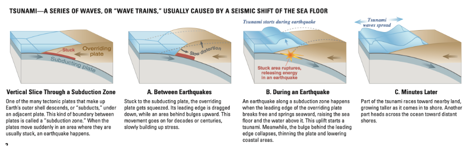
Figure 4.
Figure illustrating the mounting stress, and subsequent release, of subduction processes resulting in ‘megathrust’ earthquakes and tsunami. https://pubs.usgs.gov/circ/c1187/c1187.pdf
Aside from tectonic processes adding and uplifting rocks at the coast, the landscape of the Olympic Peninsula has been shaped by widespread glaciation during the Pleistocene Epoch of the past 2.5 million years. Continental glaciers that are today restricted to Earth’s polar latitudes expanded to lower latitudes and massive mountainglaciers extended across modern-day Washington. These glaciers carved out the landscape and carried large quantities of sediments as they expanded. Eventually, about 15 thousand years ago, the local climate began to warm and the glaciers rapidly subsided, leaving behind sedimentary deposits as they receded. These deposits constitute the sediments of the Quillayute Prairie, upon which the Quillayute Airport resides, and act as evidence of these past ice ages.
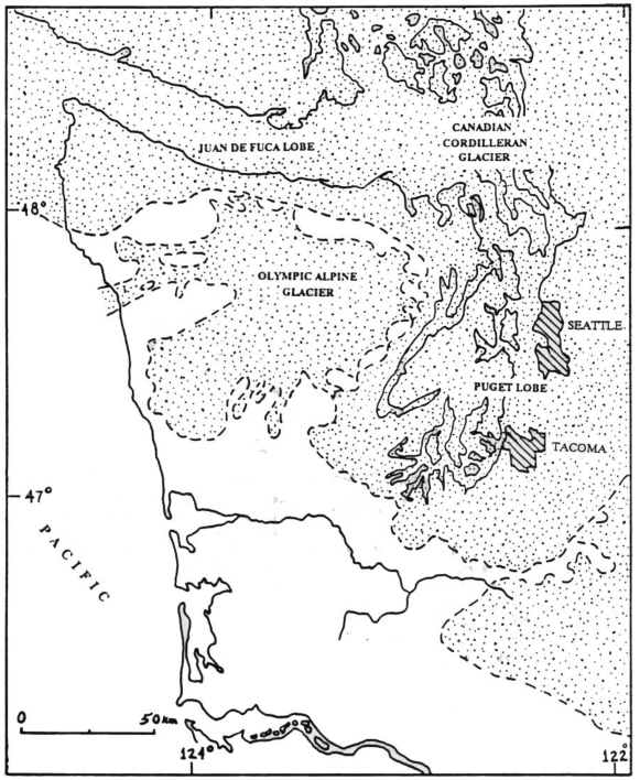
Figure 5.
Expansion of the Cordilleran ice sheet into northern Washington, showing the extent of the glaciation throughout the Pleistocene Epoch. https://www.nps.gov/parkhistory/online_books/olym/schalk/images/fig5-1.pdf
Since the end of the Pleistocene Epoch, the latest major editors of the topography have been rivers. Running water in rivers and streams is effective at carving out layers of sediment and rock over time. As the water travels, it also disperses any sediments that get swept up in the currents, dispensing them along its path. Examples of the effect of rivers and their deposits is revealed in the topography of the Quillayute Prairie, where sand and gravel were deposited by Pleistocene glaciers, and recent river systems have carved out fluvial terraces akin to sedimentary plateaus. The Quillayute Airport occupies one such terrace, located between the Dickey River to the north and the merging Soleduc, Bogachiel, and Quillayute Rivers to the south.
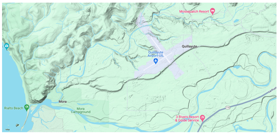
Figure 6.
Terrain map illustrating fluvial terraces where sediment deposited by Pleistocene glaciers has been eroded by river systems. Quillayute Airport resides on one of these terraces, which is marked by the distinct changes in elevation between the Dickey River to the north and the Quillayute River System to the south.
Even today, the geologic landscape of the Quillayute Prairie is ever changing, continuing to be carved out by rivers and uplifted by the subduction zone. The mounting stresses within the subduction zone will cause a megathrust earthquake sometime in the future, and current day geologists and seismologists work to assess the region’s readiness, and to prepare Washington residents for the inevitable upheaval. The earthquake early warning system ShakeAlert is one such method of preparation. Learn more at: www.pnsn.org/pnsn-data-products/earthquake-early-warning